Spring Progress and Planning for the Restoration Project at the Bulfinch
marsh
Draft
Tim Smith, Project Director
Notes - Friends of Alewife field trip - April 15, 2005
by Larry Boutiette
(below on this page)
April 15 Site walk observations and task assignments
Revised plan showing the monitoring locations discussed in
the field (Adobe Acrobat PDF file)
Adobe Acrobat reader is available free at www.adobe.com/products/acrobat/readstep2.html
The project team convened around 9am at the Bullfinch parking lot to inspect the proposed project site and discuss locations for an array of hydrologic monitoring devices.
The basic consensus was that little or no flow occurs under Route 2. Culverts along Route 2 seem to be sized for roadway drainage only, not for passage of streamflow.
Preliminary observations seem to suggest that the majority of input into the project site comes from the small ditch/stream from Little Pond and run-off from the highway and developed lots along Route 2.
Need to investigate contribution of flow, in any, from north side of Route 2.
Staff Gauge Locations:
- Nos. 1 & 2: Both sides of Acorn Park Road at entrance off Lake Street. Stew has been monitoring here. His data is referenced to the top of each headwall. The Belmont DPW has agreed to survey this spot in order to tie-in the headwalls and Stew's data to a known datum. However, Ingeborg said BSC/Bullfinch can supply, install and survey in these gauges. Belmont DPW will be asked by Stew to install Little Pond gauge (see below). David and students will collect data from these gauges.
- No. 3: Outlet of Little Pond. Stew will ask Belmont DPW to install and survey in a post in the stream at the outlet of the pond. If DPW can do this and provide us with an elevation of a known point on the post (nail, painted mark, notch, bottom of post, etc.), Tim will provide and mount a staff gauge and reference it to the surveyed point. DPW will need to locate a known benchmark for reference. David and students will collect data from this gauge.
- Nos. 4 & 5: Both sides of Acorn Park Drive at outlet of marsh. Ingeborg and BSC/Bullfinch will supply, install, and survey. David and students will collect data.
- No. 10: This gauge is in place. Need to confirm if its surveyed. David and students will collect data.
Groundwater wells:
- Nos. 11 & 13: These wells are already in place on the property adjacent to Faces. (3" O.D. steel casing with 2" pvc pipe inside with unlocked hinged caps.) Tim and Larry inspected #13 and it appears operational. #11 needs to be checked out. Is there a reason that David and students cannot or should not monitor GW in these wells? Need someone to check ownership/access and to see if prior GW elevation and survey data exists and can be shared with the project team.
- Nos. 12 & 14: Potential locations for additional GW observation wells. Both locations appear to be reasonably accessible during the growing season. Larry suggested that David check with local well-drilling contractor to see if they might provide several short sections of well screen. David will investigate possible donation or purchase. David, Tim, and Larry will coordinate on installation of GW wells. Are other GW well locations recommended?
Flowmeters: David and students will measure flow volumes at four locations:
- #7 Outlet of Little Pond
- #8 Small stream entering project site near Rt 2 and Acorn Park Drive
- #9 Outlet of Marsh
- #6 Little River near existing staff gauge
Water quality:
David and students will use multi-meter to collect several water quality parameters in conjunction with other data collection; DO, Temp, pH, conductivity, etc.
Sampling Plan:
Regular sampling should occur one per week, starting ASAP. Effort should be made to capture data during relatively wet spring periods and relatively dry summer months. In addition to weekly sampling, extra sampling should be conducted during wet weather. Need to define "wet weather", ie sampling will occur within 4-8 hours after �" rain. Ideally, data will be collected during and after various types of rain events. Rainfall data should also be tracked. If possible, data collection should continue through the summer and fall.
Other Data Issues:
Vegetation - Mapping of general cover types using GPS should occur soon, before the site becomes overgrown and inaccessible. Once the general patterns are mapped, additional inventories could be conducted during the growing season to get more detailed data on species and abundances. Tim will coordinate with David on this.
Soils - According to Larry, NRCS will conduct a soils investigation of the site. Some questions on this during the site walk: What is the difference between soils in the Typha vs. Phrag stands? What is the general depth of fill?
Mapping - Stew has paper copies of all known maps and plans for the project site and environs. Some of these may be useful in preparing a basemap for the project site. Electronic versions would be helpful. GPS could be used to supplement existing information. Tim will coordinate with Stew on this.
Task Summary:
Stew:
- Ask Belmont DPW to install post and survey elevation at Little Pond outlet.
- Provide data from prior water level monitoring
- Coordinate with Tim on basemap.
- Continue to monitor water levels, with David and students?
Ingeborg:
- Have BSC install and survey staff gauges 1, 2, 4, 5
- Get info on existing GW monitoring wells?
- See if BSC can survey elevation of new GW wells?
- Provide benchmark near site for future survey work?
David and Lesley Students:
- Investigate Obtaining 2-4 short (5 foot?) sections of well screen
- Work with Tim, Larry, and Ingeborg to install wells
- Obtain flowmeter(s) and other supplies
- Collect data throughout spring and summer
- Work with Tim on vegetation and base mapping
Larry:
- Confirm soil survey with NRCS soil scientist
- Review GW well and staff gauge installations
Tim:
- Work with Stew on base map
- Work with Dave and students on vegetation mapping
- Maintain and compile data
Notes - Friends of Alewife field trip - April 15, 2005
by Larry Boutiette
The purpose of the field trip was to view the site and comment on monitoring well and staff gage sites. While walking around the perimeter of the marsh we also commented on various drainage inputs from Route 2 and Acorn Park Drive.
It was advised to obtain Route-2 road layout maps from Mass Highway that show the intersection of Acorn Park Drive. Drainage information and recorded elevations should be on these maps.
I spoke to our NRCS soil scientist, Bill Taylor, and he is ready to visit the site to classify the soils. Bill will wait to hear from whoever is coordinating this part of the project. Since we will again be on private property, could whoever is in charge of this part of the project also notify the land owner that we will be on-site and describe to him what we will be doing. Hand borings with an augur, no equipment. Bill can be reached as follows:
William Taylor
52 Boyden Road, suite #100
Holden, Mass. 01520
(508) 829-4477 x 111
William.Taylor@ma.usda.gov
I can be reached as follows:
Larry Boutiette
52 Boyden Road, suite #100
Holden, Mass. 01520
(508) 829-4477 x 116
Larry.Boutiette@ma.usda.gov
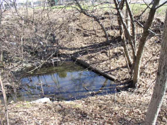
This area located just off Acorn Drive and just below the newly installed detention basin was described as a section of marsh that is relatively un-scathed and is an example of a condition to replicate elsewhere in the marsh.
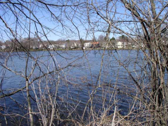
This section of the marsh has open water year round and is home for a wide variety of marsh life. Note the transition from open water to cat-nine-tails to phragmities.
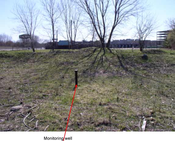
Several existing monitoring wells were located on our tour. The one in this photo is located along Route-2 just to the west of the closed former night club. It was mentioned that this might be a monitoring well established at the site of a former gas station. The well casing was 3 inch iron pipe. An approximate 1 inch diameter PVC tube is within the casing and appeared operable. There was another well located within the marsh to the southeast of this well. It was mentioned that a good site for installation of a new monitoring well would be within the marsh and approximately 200 feet to the south of the above well.
At the intersection of Route-2 and Acorn Park Drive there are a series of individual catch basins along Route-2 that outlet into a common channel. Each basin has its' own headwall structure. There is also another input into this system from a catch basin located in a grass swale between Route-2 and the Acorn Park Drive on ramp. We discussed contacting Mass Highway for discussions on the installation of water quality BMP's at this location.
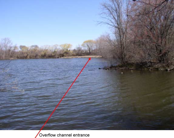
This is the overflow channel from Little Pond located on the west side of Acorn Park Drive at its intersection with and along side the on ramp for Route-2. Both sides of the culvert under Acorn Park drive were under water at the time of the visit. It appeared that the culvert entrance on the east side of Acorn Park drive was silted in from material deposited by the catch basins outlets from Route-2. This area was discussed as a possible inflow source of water from Little Pond to the marsh. For this to occur: the flow from Little Pond would have to be managed; the culvert and channel would have to be cleaned; and the channel re-graded for this to happen.
The following photos were taken at Little Pond after the site visit:
The area to the lower right of the photo is the un-controlled outlet from Little Pond. A weir type control structure would have to be constructed at this location if the level of Little Pond were to be managed to achieve flow to the overflow channel to the culvert under Acorn Park Drive mentioned above. The location of the overflow channel entrance at Little Pond is shown in the upper portion of the photo.
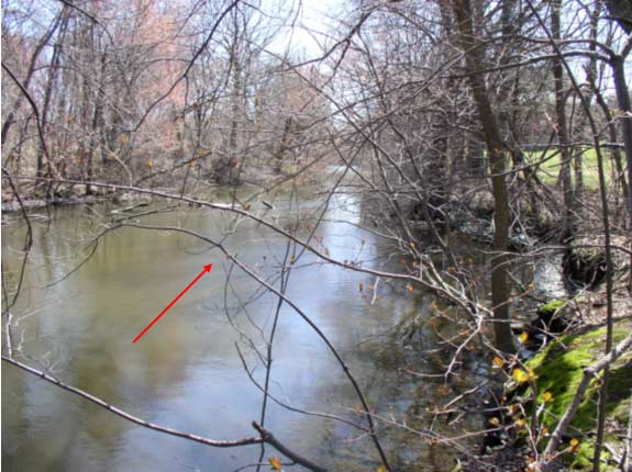
The beginning of the Little River at the outlet of Little Pond. Flow is in the direction of the arrow.
A major factor when considering a control structure and the possibility of raising the level of Little Pond is the amount of development at low elevations around the Pond. With this in mind the overflow channel may need to be graded to match the elevation of the natural pond outlet. A control structure could then be installed at the channel culvert entrance at Acorn Park drive.
|