|
Friends of Alewife Reservation (FAR) |
Search
Events News Image Collections Archive & Links (text, maps, photos) What we do (Volunteer!) About FAR Contact FAR |
|
FAR Priority status Wetlands Restoration Project (WRP) nomination form with invited Corporate Wetlands Restoration Partnership (CWRP)Partners: Bulfinch Co, regional conservation commissions, Mystic River Watershed Association, Dept. of Conservation and Recreation, and more. |
|
Adobe Acrobat version of the form (without the photos), for printing (To read the Adobe Acrobat files, you need the Adobe Acrobat reader, available free at www.adobe.com/products/acrobat/readstep2.html) The project was accepted as a priority project among many applications by state of Massachusetts Wetlands Restoration Program (WRP) of Coastal Zone Management (CZM) for further assessment and potential for funding. It was given official support by Legislator Rep. Anne Paulsen and the City of Cambridge for moving ahead towards restoration. The date of the proposal was December 15, 2004. It was given formal priority status in early January 2005. Massachusetts Office of Coastal Zone Management Wetlands Restoration Program (WRP) Project Nomination Form
This form should be used by a project sponsor to nominate a potential wetland restoration project to be designated as a priority project in order to receive assistance from CZM/ WRP. Based on the information provided as well as other available data, program staff will review the nomination with review criteria contained in the RFR. CZM/WRP may contact the project sponsor to discuss the nomination and to arrange for a site visit as necessary. The sponsor will be notified in writing of the decision to accept or reject the potential restoration project as a current program priority after the review is complete. Please fill out the form as thoroughly as possible and return to the address below. Contact CZM/WRP with any questions. Thank you for you interest in restoring Massachusetts wetlands!
(Attach additional sheets as necessary) Site Name: Little River and Alewife Reservation_______________________________ Site Location: City/Town: Cambridge________________________________________ Nearest Road(s): Route 2/Acorn Park Drive_______________________ Adjacent Waterbody: Little River/Perch Pond______________________ Location Notes: The Little River, Perch Pond, and associated wetlands are part of the MA Department of Conservation & Recreation Alewife Reservation and are partly owned by BHX, LLC, Trustee of Acorn Park Holdings Realty Trust, an affiliate of Bulfinch Companies, Inc. The location of the proposed restoration activities is in the area of the former Acorn Park, now known as Cambridge Discovery Park.___________ *Please attach a USGS topographic map with the site location clearly marked. If available, also attach current and historic photos, maps, and aerial photos of the project site.
Project Sponsor: Friends of Alewife Reservation _____________________________ Designated Representative: _____________________________________________ Name: Ellen Mass____________________Title: President________________________ Address: 104A Inman Street________________________________________________ City/Town: Cambridge _____Postal Code: 02139____________________ Day Phone: 617-547-1944 Email: elnmass@comcast.net
Landowner(s): MA Department of Conservation & Recreation (DCR)______________ BHX, LLC, Trustee of Acorn Park Holdings Realty Trust.(BHX)___ ____
Has landowner expressed support for wetland restoration at the site? Yes _X_ No __ Explain: The potential for restoration of wetlands associated with the Little River and the Alewife Reservation is significant as a result of DCR restoration goals for the Alewife Reservation, as set forth in its Master Plan, prepared by The Bioengineering Group, Inc, and as a result of Bulfinch’s interest in contributing to wetland restoration on its property. BHX has expressed support for the restoration of a large emergent marsh located on its property that is currently stagnant and dominated by invasive species, including Phragmites. This wetland is called the “central wetland”. (go to next page) Project Description: Briefly describe the history, current condition, and restoration needs of the wetland and surrounding landscape. What impacts have damaged the wetland? What is the extent and severity of the damage? What size is the area proposed to be restored (acres)? Describe what physical actions are needed to restore the wetland? What restoration efforts have already occurred? Are there practical and/or political issues that may present significant challenges for this proposed restoration?
See Exhibit A, which includes a discussion of the history of the site, the current proposed redevelopment activities, a description of the wetland resource areas on the property, and a summary of data available for restoration efforts. Exhibit A also describes the current discussions regarding restoration goals for the Central Wetland and what efforts have been initiated.
Is any part of the site subject to compensatory mitigation or enforcement order? Yes___ No _X_ If yes, explain: not applicable
Has any funding been identified for this project? Yes_X_ No___ If yes, describe: BHX has volunteered to contribute a cash donation to assist in the further development and implementation of restoration goals of the Friends of Alewife (FAR) and the DCR in the implementation of its master plan.
Have any other restoration partners (actual or potential) been identified? Yes_X_ No__ If yes, please state their status in relation to the project and include contact information: The sponsor is currently discussing joint sponsorship with the City of Cambridge and the MA Department of Conservation and Recreation (DCR), and further hopes to include the Mystic River Watershed Association, and other private landowners._________________
Signed: ________________________ Date: _______________
Please send this form with attachments to: Hunt Durey Wetlands Restoration Program (617) 626-1200 251 Causeway Street, Suite 800 wetlands.restoration@state.ma.us Boston, MA 02114 A representative of WRP will contact you shortly. Please call or email us if you have any questions. Exhibit A
Introduction Alewife Brook and the Little River are anadromous fish runs. The herring runs have been a major event in the Alewife Reservation area. However, over the past few years, the herring have declined. The Little River has become increasingly shallow and local advocates speculate that the river may be less suitable for herring as a result of stormwater runoff and associated deposition.
The history of the Little River and the associated emergent marshes is typical of urban wetland marshes. However, recent changes in land development patterns and unique opportunities to reverse the historic degradation make this area a prime candidate for the Priority List for Coastal Wetland Restoration program.
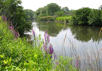
Based on an old Sanborn map, it appears that the Little River originally ran through the Central Wetland until the river was relocated to its current location as a result of state-sponsored dredging and widening in the early/mid 1900s. The riverbanks are straight and fairly steep, and until recently, have been largely lined with office buildings.
Political Conditions As a result of recent zoning changes addressing the redevelopment of Acorn Park, many office buildings, as well as a large parking area adjacent to the river and associated wetlands, will be removed over the course of the next 10 years, and the areas returned to a natural state. In addition, the MA Department of Conservation and Recreation (DCR) recently completed a comprehensive Master Plan for the urban wilds of the Alewife Reservation. Locally, a major tri-community effort (Arlington, Belmont, and Cambridge) is in place for finding solutions to the flooding at Alewife. The support of BHX will further foster the collaboration between the three communities and result in measurable improvements to the Little River and Alewife Brook.
The City of Cambridge has proposed a stormwater management basin designed to treat stormwater and improve water quality in the watershed area by upwards of 90 percent. This design is now moving forward through the permitting process. Finally, the Federal Emergency Management Agency (FEMA) is in the process of calculating and updating the 100-year storm event in the area.
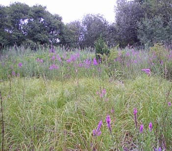
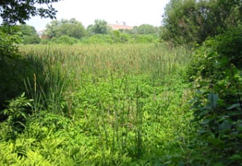
Natural Resource Conditions A large emergent marsh is located on private property, owned by BHX, an affiliate of Bulfinch Companies. This wetland has been called the Central Wetland due to its central location and is approximately 10 acres in area. As such it is the largest wetland area in Cambridge and possibly, in the region. It is now largely stagnant and supports a monoculture of invasive species, including Phragmites and Purple Loosestrife. Historically, even as late as the early 1900’s, this area was a diverse emergent marsh with an unrestricted flow to Boston Harbor, providing food, cover, and breeding habitat to a diverse wildlife community, including anadromous fish. The current Phragmites reed marsh contains vernal pool areas, and has the potential to regain some wildlife diversity, and, in conjunction with protected upland habitat, creating a unique breeding and foraging habitat for the species that have started to repopulate the reservation.
The Central Wetland receives stormwater drainage from Route 2 and from a pipe connecting the wetland to land in Arlington, located to the north of Route 2. The current stagnant conditions have resulted in a general degradation of ecological conditions. One goal of restoration is to improve the hydrologic pulsing to this wetland to encourage a more diverse ecological community and to create a more efficient flood plain for consistent flow to Little River. Other restoration options are being discussed in an effort to manage the invasives, improve stormwater quality, address flooding issues, and improving the quality of the Little River to restore anadromous fish runs.
Overall Restoration Goal There are several wetland restoration options that will contribute to the local, state, and private restoration efforts. Restoration efforts can include riverbank restoration, emergent marsh restoration, and restoration of wetland wildlife habitat.
A restored wetland of approximately 10 acres will have a positive effect on the entire Alewife Reservation and downstream communities. The restoration of the Central Wetland would work in conjunction with the DCR Master Plan initiatives and the City of Cambridge’s stormwater management improvement plan. By ameliorating upstream conditions at the reed marsh, and improving riparian drainage, an offshoot of the restoration via removal of invasive species, a significant improvement to the ecological conditions of the entire watershed can be expected. The upstream town of Belmont also plans to improve its water quality drainage in the next year, further contributing to the restoration activities.
Available Data The following data is currently available for use in restoration planning and design: the wetlands have been flagged and approved by the Cambridge Conservation Commission, some topography is available in the buffer zone to the wetlands and along the banks of the Little River, the stormwater drainage system has been studied and evaluated in terms of pipe sizes, slopes, and inverts, and a preliminary assessment of wetland functions has been conducted. In addition, preliminary research into Phragmites management has been initiated with respect to improving on the stagnant conditions by increasing flow into the wetland.
Development of a better understanding of the 10-acre wetland through restoration planning and design will aid in these efforts. As the entire Little River falls within the 100-year floodplain, a key issue that must be addressed in the restoration of the central wetland is to ensure that floodwaters are not backed up through the pipe(s) beneath Route 2 to exacerbate flooding in Arlington.
Support Requested of the CWRP There are several areas in which the CWRP could assist in this collaborative effort. Some ideas are listed below, in no order, and are not comprehensive or meant to be limiting: · Hydrologic analysis of Central Wetland, including evaluation of redirecting flows through wetland · Invasive species management · Sediment testing to evaluate dredging potential · Topographic survey of Central Wetland · Community education and training · Wildlife management implementation · Construction of improved storm drainage structures or new drainage structures
Attached to this text is a site locus U.S.G.S. map, a 1906 U.S.G.S. topographic map, an aerial photograph, and an undated aerial photo (presumed to be in the 1950’s) showing the construction of Acorn Park Drive. Note on January 8, 2005: We plan to add the above-mentioned attachments to this website at a later date. The photos below are related to this form.
|


