Events News Image Collections
Archive & Links (text, maps, photos)
What we do (Volunteer!)
About FAR
Contact FAR
|
|
Friends of Alewife Reservation (FAR) |
Search
Events News Image Collections Archive & Links (text, maps, photos) What we do (Volunteer!) About FAR Contact FAR |
Mammal Survey
This page is intended for viewing on the Web.
For printing, especially because of the wide tables in Appendix A, we suggest using either of these versions: Adobe Acrobat or Microsoft Word. The Adobe Acrobat version can also be viewed on the Web. (To read the Adobe Acrobat file, you need the Adobe Acrobat reader, available free at www.adobe.com/products/acrobat/readstep2.html)
Mammal Tracking Survey
2002
*******************
Alewife Reservation
 |
The Friends of Alewife Reservation
Conducted by: David Brown’s Wildlife Services
Carlisle, Mass.
Funded by: The Riverways Small Grants Program
Massachusetts Department of Fisheries, Wildlife and Environmental Law Enforcement
TABLE OF CONTENTS
Background…………………………………………………….…...………page 1
Purpose
Method
General description of the land
Beaver
White-tailed deer
Eastern coyote
Red fox
Cottontail rabbit
Mink
Housecats and dogs
Water
Small fields
Contiguous, unbroken natural area
Aspen groves
Public walks
Trails
Kiosks
Nature trail
Covered instructional area
Observation tower
Observation blinds
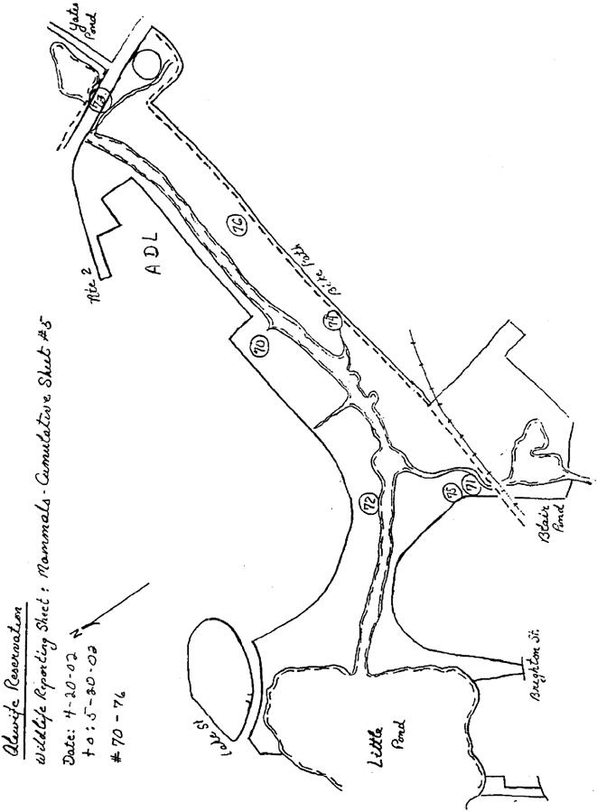
A. Cumulative database
B. Data interpretation
C. Charts of sign locations
ALEWIFE RESERVATION-2002
Commissioned by the Friends of Alewife Reservation
Funded through the Riverways Small Grants Program
Massachusetts Department of Fisheries, Wildlife and Environmental Law Enforcement
Conducted by David W. Brown
David Brown’s Wildlife Services, Carlisle, Mass.
Mammal Tracking Survey of Alewife Reservation-2002
This inventory was commissioned by the Friends of Alewife Reservation and funded through a grant from the Riverways Small Grant Program, Massachusetts Department of Fisheries, Wildlife and Environmental Law Enforcement.
During the winter of 2001-2 a grant from Riverways was sought and acquired by the Friends of Alewife Reservation to conduct two wildlife inventories in the park, a mammal tracking inventory and a combined migrant and breeding bird survey. The inventories were conducted from March through June 2002 by David Brown of David Brown’s Wildlife Services, who had previously conducted a tracking survey of the nearby Middlesex Fells Reservation. Two separate reports have been prepared. As each report is intended to stand alone, some information is duplicated, appearing in both studies.
Purpose. The intent of the survey was to determine, through the track record, the species of wild mammals that were present in the reservation during the winter and early spring of 2002. This information could then be used both as a source of information with which to draw public attention to the reservation as a wildlife resource, to inform programs in wildlife education for the public and to help design future management policy.
Method: Originally it had been expected that perhaps 3-4 visits under ideal tracking conditions, along with one or two spring visits for “other sign”, would be sufficient to determine wild mammal use of the reservation. However, authorization for the inventory was not granted until late winter, after which date only two very short snow events occurred, the accumulation of which lasted too briefly to record many tracks. Instead, mammal presence had to be determined by detection of sign such as scat, browse, burrows and other digs, evidence of predation, etc. as well as tracks in soft spring mud.
While the results cannot be as detailed as might have been the case with more snow, it is felt that the survey gives a good idea of the mammal population in the park, as well as an adequate idea of species use and requirements.
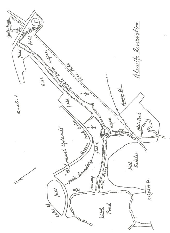
General description of the land: topography and vegetation. Alewife Reservation is an urban wild surrounded by industry, heavy-use roadways, office parks and human residences. It is located in the Boston basin, an area that in its geologic history apparently sank under the weight of glacial ice and thereafter accumulated the fine silt that settled out as the final product of outwash from inland glaciers just before their meltwater entered the ocean. Where this silt is saturated by the aquifer, it forms an underlay of clay. Since the end of the last glacial period, however, the area has been subject to alluvial influence with deposition from periodic flooding that leached out minerals from inland and upland locations, depositing them in a rich black soil over the clay underlay.
Today Alewife Reservation is for the most part floodplain for Little River and Alewife Brook. Historically part of a large marsh abutting Fresh Pond, the area has been progressively filled for construction, so that today there is little terrain in the park that has not been disturbed. The Little River, which drains Little Pond, itself fed by Winn Brook and Spy Pond, receives inflow from Blair Pond via Wellington Brook, as well as from a number of sewer discharge conduits. The river was relocated from its meandering natural course and straightened into a channel with steep banks, apparently to prevent flooding and to better serve as a conduit for runoff and sewerage into the Mystic River downstream and ultimately into the ocean. At the east end of the park, Alewife Brook enters the river via a ditch from a culvert at the edge of the park’s boundary near the T-station.
Relocation and channeling of the river in the past has reduced the frequency of flooding but the vegetation types found in the park still reflect a history of periodic inundation. Specifically, the dominant forest type is composed of floodplain species such as silver maple and black willow as well as red maple, all species that can survive total saturation of the soil in which they grow.
A high burm, which at one time elevated a railroad track, runs along the south boundary of the reservation. This burm currently supports a dirt bicycle path as well as some of the few non-floodplain trees present in the reservation, specifically several medium-age scarlet oaks. One large red oak grows in the northwest section of the park, called the “Belmont Uplands” and a number of planted pin oaks, a species not native to this area of New England, line the former Arthur D. Little property on the north bank of the Little River in the middle of the reservation. The relative absence of oaks in the park has consequences for its mammal composition, specifically it results in a lower gray squirrel population than is the case in upslope woodlands elsewhere in the region. This has ramifications for squirrel predators, as well, specifically the absence of fisher sign, a predator that has been attracted to other metropolitan parks in the area by high squirrel populations.
Many cherry trees are scattered around the park, including one substantial stand of black cherry in the woods near the northeast shore of Little Pond. These were probably escapes from homesteading in earlier times since these trees, valued as furniture wood and for tool handles, were often planted around residences as a money crop.
Apple trees are also frequently found in the park, mostly at its western end, apparently relict from an orchard that existed in the area many years ago.
Aspen, or “poplar” as the two native species are called in New England, are found in several areas of the park. The most extensive stand is at the eastern end of the reservation south of the river. However another small grove exists south of Perch Pond and a third at the northeast corner of Yates Pond, with many individual trees scattered around the park. These trees are regarded as successional, creating shade under which they themselves cannot reproduce and thus preparing the way for more shade tolerant species to follow. The presence of two pure stands in the floodplain is probably a function of the frustration of the natural periodic flooding of the area, a factor that has allowed this species to make advances in the more open areas of the park, especially at its eastern end. Aspen are a favorite food for beavers and apparently constituted the attraction to the animals resident in the park at the moment. The effect of beaver cutting on the future of these stands will be discussed below in the section on this mammal.
Many other species of trees are present in small numbers on the reservation. Norway maples and boxelders, neither native to the region, are probably escapes from the cultivated trees that were planted along city streets to replace the elms that were devastated by the Dutch elm blight. A number of fairly mature ashes can also be found scattered around the floodplain.
Interestingly, few conifers exist in the park. The only ones that are present were planted as landscaping on the property of abutters and are so scarce that they do not serve as a significant habitat for species that prefer this forest type.
At most, the western sections of the park can be described as open woodland; nowhere except in the extreme northwest portion is there anything like a closed canopy. The eastern section is more open and marshy, with the exception of the monoculture of aspens in one extensive grove.
In the more wooded sections of the park undergrowth varies with sunlight at the surface. Under the silver maples in the northwest section there is relatively little, with bare alluvial soil visible under dead leaf cover. In more open woodlands in the western part, are a variety of bushy species like honeysuckle, with dogwoods and European buckthorn, an invasive, proliferating along the river. Pussy willows and alder grow in the marshy areas at mid-river. Sumac genets are very common everywhere in the park, in some places amounting to monocultural growth with individuals occasionally growing to the stature of trees.
Many small cattail marshes exist especially in the wet impoundments on both sides of Little River in the middle of the park. However, another exists along the northeast shore of Little Pond and a third at the west margin of Yates Pond. All these marshes are under siege by invasives as will be discussed below, particularly purple loosestrife. Pure stands of giant reed (fragmites) and Japanese knotweed are spreading in the bottomlands, with latter concentrated at the east end of the park and along the burm south of the river.
Lack of snow meant that rather than visiting the property on several occasions under ideal tracking conditions (several days after snow but before additional weather), numerous visits had to be made to relatively small areas that had to be searched intensively for sign. As a result, a departure from the specified report format seemed advisable in the interest of readability and usefulness, specifically the omission of a narrative for each site visit.
Despite the handicap of lack of snow during the study period, it is felt that the survey gives a good picture of the mammal populations that use and inhabit the park. Certainly there was enough evidence to support the contention that Alewife Reservation supports a much larger wild mammal population than might be expected of an urban park.
Evidence of common urban mammals, such as gray squirrels, chipmunks and raccoons, was not noted every time it was discovered, nor was evidence of woodchuck. It should be assumed by the reader that sign of all these species or the actual animals were frequently seen in the park.
General assessment:
Although only 115 acres in size, there are places within Alewife Reservation where one can feel removed from the intense civilization surrounding it. In such places, with a half-dozen birds singing in the trees and bushes and sign of wild mammals and other wildlife at hand, it can provide a natural experience to the urbanite without the need to travel far from home or work. Indeed the park hosts an unexpected abundance of wildlife. Water and sunlight, both available in abundance, promote dense growth at ground level, which in turn provide cover and food for many wild animals. Large areas of the park are isolated from heavy visitation by natural and man-made obstacles as well as by the wetness of the terrain and its widespread cover of dense brush with thorny blackberry canes and poison ivy. The presence of several small fields in the park and a relatively low predator population has resulted in abundant meadow voles and cottontail rabbits, forming a prey-base available for exploitation by a number of predators.
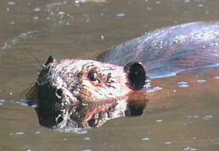
Despite the current degraded condition of the water that flows through the park, muskrats manage to utilize it effectively as do resident beavers. Raccoon tracks are common along the banks and sign of mink is occasionally found there as well.
Urban parks are sometimes disparaged as “squirrel parks”. (Ironically, although gray squirrels are locally common in this park, their overall population is low relative to other wooded areas in eastern Massachusetts, the result of a lack of many mature acorn bearing oaks or hickories.) Looking at the results of this inventory, it would appear that the term “urban wild”, in this instance at least, is fully deserved.
In the past decade many wild animals normally associated with the distant wilderness have been quietly moving closer and closer to the Boston metropolitan area. Sign of such species as beaver, otter, fisher, mink, weasel, coyote, fox, deer and so forth are being found throughout the area. A number of factors have been cited to explain this trend. The long, slow rematuration of the eastern forest, since the decline of agriculture in the mid 19th Century and the last great natural disturbance, the hurricane of 1938, has certainly contributed. Old oak trees mean many acorns; many acorns mean gray squirrels and their predators: hawks, fishers, coyotes, foxes. The availability of succulent suburban ornamental shrubbery and the brushy edge created by housing incuts into woodlands has provided ideal habitat for white-tailed deer. Improvement of waterways has created healthier environments for fish, mollusks and crustaceans, which in turn have drawn their predators: otters, mink, raccoons and migrating osprey, among others. The attention currently being devoted to creating and maintaining fields in the Commonwealth has meant habitat for rabbits, voles, woodchucks and their predators: fox, coyote, hawks and owls.
While we may think it inappropriate for these wild animals to take up residence in the city, they will gravitate to any area that provides them with the necessities of life: food, water and cover. When young animals disperse from their natal ranges they are not provided with a road map to promising areas for colonizing. Instead they follow their nose in the direction of usable habitat and the food it provides, unaware that their nose is leading them into the eastern megalopolis.
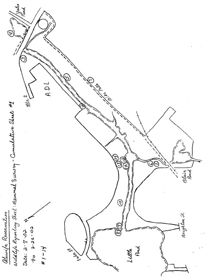
A beaver bank burrow as well as cuttings were discovered within the last year along the Little River across from Arthur D. Little. The animals appear to have been attracted to the area by the many aspen, a favored feed tree, growing in the reservation. The inventory found cutting sign the length of the park, mainly in the aspen groves at the east end and on the south bank of Perch Pond. Some desultory cutting of shrub dogwood was also found along Wellington Brook. It is clear that these animals are using the stream complex as a linear habitat (see Figure 1).
One small dam was discovered in the feeder brook that enters the Little River from the north at its mid-point in the park. This dam has been freshly mudded and so is clearly being maintained. Its potential for flooding, however, is minimal, given the character of the terrain in the area.
Beavers do not build dams out of habit. They do so only to bring themselves close to food. While dry land is a danger area for these cumbersome animals, water means safety, and so they try to exploit, or create, water access to food wherever they can. If they don’t have to build a dam to flood their way to favored growth, they won’t. As flat wetlands are very difficult to dam and many aspens are close at hand to the river, it is unlikely, in the near future at least, that these beavers will represent a threat of flooding for low lying homes and businesses.
By cutting aspen, beavers ironically may create conditions for the perpetuation of the stands. As mentioned above, aspen are usually a temporary species of tree that creates shade for more durable trees to follow. By cutting them the beavers admit sun to ground-level, providing light which aspens need in order to regenerate under themselves. It remains to be seen whether this regrowth can match the rate of cutting and so provide habitat for a continuing presence of beavers in the reservation.
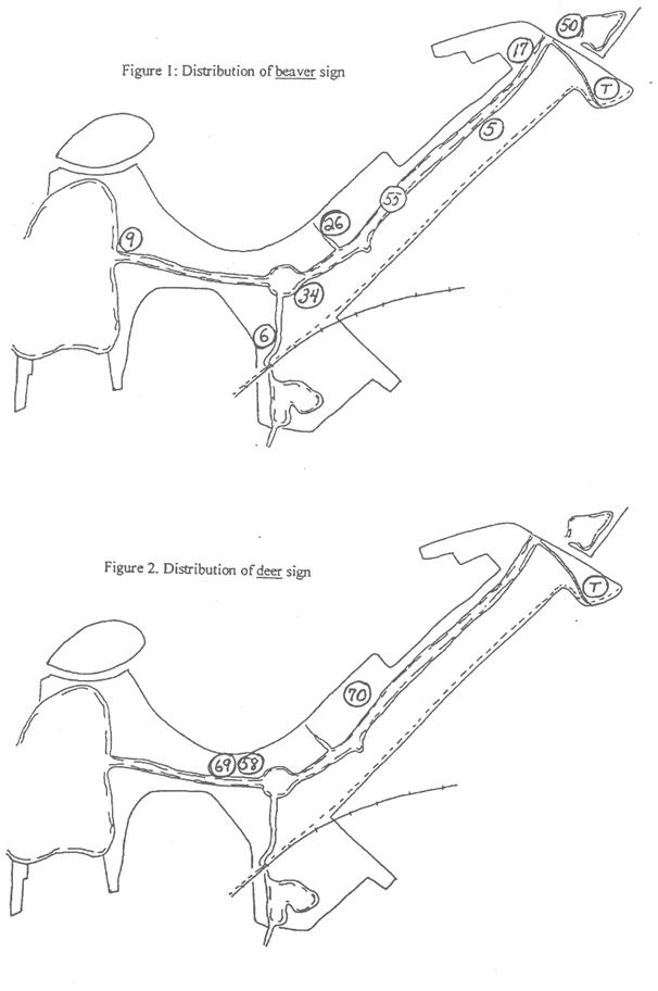
Spring/summer scat and browse sign was found in the field at the northwest end of the park and several old buck rubs were also found near a field at mid-river on the north side (see Figure 2). All of this sign was at least a year old. Anecdotal evidence also indicates sightings north of the river in the past. Field such as the ones mentioned often attract deer in the spring as they contain grass and herbs that green very early, providing feeding opportunities for deer that have been on the verge of starvation through the winter. No fresh sign was found in these fields during the inventory, however, suggesting that the presence of deer in the reservation is intermittent.
Several scats and tracks of this species were found in the reservation, north of the river. In addition, anecdotal sightings have been made recently in Mt. Auburn Cemetery, a mile to the south and on Beacon Hill (news videotape). Examination of several scats found in the reservation indicate that, at this point at least, these animals are feeding exclusively on natural prey. All the scats but one consisted of fur and bones. One vole mandible was found in the freshest of the deposits. (One ambiguous scat, attributable to coyote only by location, consisted of part of a plastic bag.) Two sites along the Little River on the north bank suggest that local coyotes may have adopted the habit of preying on Canada geese, as well, by lying concealed next to the river until a goose comes close and then plunging into the river, seizing the goose by the neck and dragging it ashore. This is a tactic that has been demonstrated elsewhere in eastern and central Massachusetts, and apparently is being used on the abundant Canada goose population here.
It appears from the evidence that coyotes are visiting the reservation periodically to hunt the fields for voles and rabbits. Circumstantial evidence suggests the “Belmont Uplands” silver maple woods as likely for temporary lay sites, as this is the most remote part of the park from human and dog intrusion and is adjacent to several productive fields.
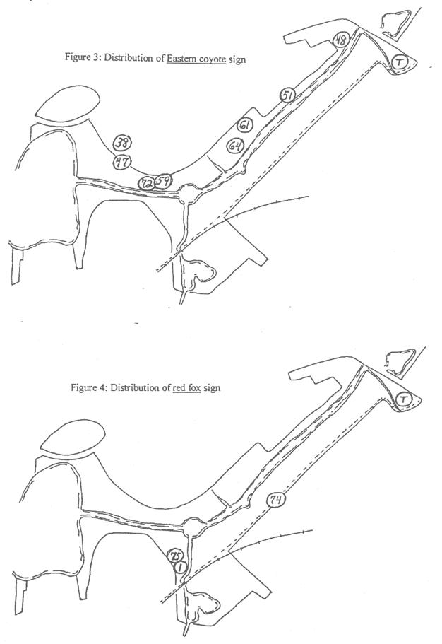
No sign was found on the south side of the river, perhaps not coincidentally the location of the only red fox sign found during the tracking inventory (see Figures 3, 4). As there is a population of at least four feral cats that hunt the south side of the river, and as coyotes are known to prey on cats, both from antipathy for food competitors and as food themselves, a spread of coyote activity to the south side of the river may have welcome consequences.
The evidence at Alewife and elsewhere in the metropolitan area suggests that, initially at least, coyotes prefer to remain wild, concentrating on natural prey items. However, these are very intelligent and adaptable animals that will learn to exploit any food source made available to them. They also quickly learn to overcome their natural fear of humans where they are not molested. Given the traditional laxity with which urbanites dispose of food scraps as well as the density of this food source, it has to be expected that the future holds the promise of closer and closer encounters with this species in urban areas, encounters that may not always be satisfactory for either species.
Several scats consistent with red fox as well as one scent mark were found near Wellington Brook, at the west end of the reservation. While this evidence was not totally conclusive for the presence of this species, anecdotal reports from the past suggests periodic visitation, apparently in search of meadow voles and rabbits in the fields and field edges. Convention wisdom indicates that red foxes will not persist in areas that are invaded by Eastern coyotes. At present all sign of coyote is north of the river and all red fox sign is south of it (see Figures 3 and 4). This may be a situation in transition as coyotes are attracted by rabbits and voles to the south side as well.
This species is currently abundant in the grassy and brushy areas of the park. The fields at the east end of the park, in fact, showed extremely high density of both tracks and scat after a brief late-winter snowfall. However, lagomorph populations are notoriously subject to peaks and troughs, and so the presence abundance is certainly temporary. Apparently until fairly recently the predator-prey ratio has been quite low, with red-tailed hawks and red foxes taking advantage of the surplus. Mention of feral cats and occasional great horned owls in the literature of the park suggests that historically they too have taken rabbits during periods of abundance. Add to these predators the recent arrival of coyotes as well as the presence of mustelidae like minks and long-tailed weasels, and the balance may be on the verge of shifting.
Scant sign of this species was found during the survey, but its occasional presence is supported by anecdotal evidence and by the population of muskrats on which mink often prey. Minks are less dependent on fish than are their larger cousins, otters. In addition to muskrats they also prey on ducks and will hunt areas adjacent to water for land prey such as voles and rabbits. In contrast, otters, the sign of which was not found during the survey, are much more dependent on fish, crayfish and mussels.
Housecats and dogs.
The impact of pets on wildlife populations can be considerable. At the moment sign of domestic dog is mostly restricted to the bike path. Where coyotes are present, dogs seem to learn to stay close to their masters. One visitor was encountered who regularly walks dogs off a leash on the north side of the river, bushwhacking resolutely through brush, wetland and brambles in the most sensitive parts of the park. Several apparently feral cats patrol the south side of the river, probably hunting birds as well as mice, voles and perhaps rabbits. With respect to feral cats, the recent appearance of eastern coyotes in the reservation may reduce their activity. Coyotes are know to regard cats as a food source, and the cats at Alewife are particularly vulnerable since in an open wetland, cats have few trees to climb in order to escape. Perhaps significantly, most of the cat activity was found south of the river while all of the coyote activity found so far is on the north side.
Significant habitats:
Water. It belabors the obvious to point out that water is the fundamental habitat at Alewife Reservation. In fact, it is the rationale for the existence of the park: the rest of the lowland area in the vicinity has been filled and built upon over the centuries, leaving only the extreme lowland adjacent to the Little River in a somewhat natural state and available for public protection. Despite the highly polluted condition of the water, it does sustain life both within it and along its edges. Muskrats have managed to tolerate the conditions, feeding on emergent vegetation along the shores. Where muskrats proliferate, mink will be found, as well, being the rodent’s principal predator. The presence of beavers has been celebrated in the local press recently. These animals occupy a bank burrow in the Little River and are treating the connected waterways of Little River, Yates Pond and Wellington Brook as linear habitat. Quite a few Eastern painted turtles have been observed sunning on partially submerged snags in the river but, ominously, few frogs have been heard in the spring when they should be vocal. A great many very large introduced carp plow the deep muck on the river bottom, increasing the turbidity of the water. Numerous Canada geese in the river have attracted the attention of Eastern coyotes, which have developed tactics in recent years for successfully preying upon them.
Small fields. In addition to the two obvious fields on both sides of the Little River near the T-station, several other small open areas dot the reservation, some so hidden from casual view that they receive few human visits. In addition to the grassy open areas, these fields are valuable for their edges, areas where abundant sunlight and availability of a seed source creates a brushy border, which in turn provides browse and cover for mammals. Collectively the fields in the reservation represent significant wild mammal habitat. All abound with meadow vole runways, cottontail rabbit feeding sign and scat as well as woodchuck dens. The presence of this large prey base has attracted many predators to the area. Red fox and Eastern coyote as well as long-tailed weasel sign has been found in these areas. Mink probably hunt them as well, since all are near water. Although the found sign is old, it is clear that white-tailed deer have used these fields, probably for spring forage, in the past. This is supported by anecdotal evidence.
Contiguous, unbroken natural area. Large areas for denning and resting during the day are important for many wild animals that require space and seclusion from human interaction as well as interaction with others of their own species and species with whom they compete for food. How large an area is sufficient to constitute a refugium depends on the species, the character of the area and the richness of nearby habitat. Accurate data for this sort of size estimation is hard to come by. Typically the critical threshold is discovered only after development, disturbance or encroachment reduces the size of the refugium until species once present are no longer found. At present the largest such area is north of the river, at the west end of the reservation, in a stretch of floodplain woodland and marsh locally known as the “Belmont Uplands”. This area, which is composed of both property on the reservation itself as well as private holdings, should be thought of as part of the Greater Alewife ecosystem. Wild animals are unaware of property lines; for them this is one entity, broken only by Acorn Park Drive, an access road to the former Arthur D. Little campus. It enjoys the great advantage to terrestrial mammals in that it is isolated from intense human visitation, and consequently, by their pets as well, surrounded as it is by Little Pond to the west, Rte. 2 to the north, Little River to the south and ADL to the east. Concentrated sign of Eastern coyote has been found here, some of it fairly fresh, suggesting a bedding area, as these animals work the greater reservation and undoubtedly Fresh Pond as well as the local cemeteries.
Aspen groves. One large aspen grove covering about an acre exists on the south side of the river near the east end of the reservation. Several other smaller satellite groves exist through the park, significantly at Perch Pond and Yates Pond. These groves are natural oddities, growing as they do in marshy floodplain. Aspens are pioneer tree species, succeeding out into abandoned fields in the process of succession by which such open areas revert to forest. Only the channelizing of the Little River to prevent flooding has permitted this pioneer species to grow in a former wetland close to the river. Aspen in the park are the principal attraction for beaver and undoubtedly the reason for their presence here, as this is the animal’s favorite feed tree. Cutting both near the bank burrow and up and down the river may have the effect of perpetuating this “temporary” species. Aspen is classified as a pioneer species because it cannot reseed in its own shade. Once it grows up, ironically it cannot reproduce under itself, setting the stage for succession by more shade-tolerant and long-lived species to continue the process of return to forest.
The contrast between the interior of the reservation and its surroundings is dramatic. With only a few steps one can leave buildings, traffic and industry behind and enter into a different world. The presence of such a resource in the middle of a metropolis can provide excellent opportunities for urbanites to experience real nature. Dogs, cats and squirrels are replaced by rabbits, beaver and muskrats. Pigeons and house sparrows are replaced by red-winged blackbirds and yellow warblers.
Public walks. The Friends of Alewife, who commissioned this study, already provide a number of public walks, with more to follow now that a cadre of docents has been trained to conduct them. Frequent walks contribute to the public impression of citizen concern for the park. Displaying its wildlife content will improve the public perception of the park from a party site or place for illegal dumping to a valuable urban wild.
Trails. With the cooperation of the Metropolitan District Commission, the state organization with management responsibility for the park, a system of more formal trails to replace the haphazard maze of “informal trails” that lace the park may be constructed.
Planning for these should be careful to enhance rather than degrade the wildlife habitat in the park. There is an inherent conflict in the term “wildlife education”.Too much close public access to too much of the park is likely to reduce its wildlife potential, while too little access will keep its wildlife content invisible to the public.
Alewife Reservation is not a wildlife sanctuary. However, some things can be learned by the arrangement of trails at Audubon Sanctuaries as well as at state parks, such as Wachusett State Reservation, where easily damaged natural features exist and where both the public and wildlife are successfully accommodated. In these sanctuaries public access is restricted to well-defined trails, and departure from those trails is actively discouraged. Furthermore, the trails are spread out to allow for considerable undisturbed habitat in between.
In the case of Alewife, public recreation by users uninterested in its natural or esthetic content has the potential to seriously degrade wildlife habitat through perfectly legitimate overuse. Here the practices at the sites mentioned above can be augmented to avoid facilitating such use. Establishment of loop trails should be avoided and those that already exist obstructed. Instead, salvage the existing informal trails system in such a way as to create a number of T-trails, that is, trails that go from a trunk trail, such as the bikepath, to circumscribed viewpoints where they end. Note that this does not represent an effort to prohibit other use, but rather an effort to avoid facilitating it.
At present the north side of the river receives much less visitation than the south side, making it a somewhat better habitat for terrestrial wildlife. Building a loop trail with a bridge across the Little River not only would increase human impact in the most secluded parts of the reservation but would also allow pets, especially feral housecats, easy access from the south side to which they are currently more or less restricted.
Members of the Friends of Alewife and others concerned for the reservation should spend as much time visiting the park and walking the trails as possible. Their presence will help to discourage illegitimate use and give the general impression to visitors of a park that is cared about.
.
Kiosks. The excellent informational kiosk at the T-station might be supplemented by additional ones at other access points. Consider replacing some of the printed information with pictures of wildlife present in the park. Creating seasonal montages displaying representations of the “Mammals of Alewife” or birds, wildflowers, trees, and so forth, will catch the eye of passers-by better than straight text and intrigue them with the unsuspected wildlife content of this urban the reservation.
Nature trail. A “nature trail” in the form of rough plackards on posts or wired to trees can be spotted along the trunk trail, T-trails and viewpoints. Each station should direct attention to a natural feature perceivable directly or indirectly from that point and contain a picture and printed information about it. It is suggested that the plackards be constructed from scrap wood to which is stapled laminated information sheets. (Be careful to staple through the clear border. Stapling through the paper area will break the seal and allow water to leak in and discolor the sheet.) A store of plackards and a file of masters should be maintained by a committee for quick and cheap replacement of removed or vandalized stations. Leaving vandalized signs in place for any length of time contributes to a feeling of neglect in the park. If enough volunteer energy is available, consider placing some plackards to display conspicuous wildlife that is only seasonally present, such as yellow warblers along the river in spring, removing the plackards at other seasons.
Covered instructional area. There seems to be some interest in building a roofed, open-sided pavilion in the park. It is suggested that this be sited within a short walk from the T-station, but concealed from it so as to limit its potential for illegitimate use. A location that muffles traffic noise in order to create a sense of seclusion and change of atmosphere from the surrounding city is suggested.
Observation tower. A tower at one of the T-trail viewpoints along the south side of the river is a possibility. From such a point one could see into the growth on the opposite shore from an angle favorable to wildlife observation without intrusive disturbance of the observed. Once again its potential for illegitimate use and vandalism must be considered in budgeting of maintenance funds as well as available volunteer energy for maintenance and repair.
Observation blinds. These have been suggested as well. Siting and use of such blinds is complex, however. Poor siting will result in little observation while misuse will result in “spoiling” the blind, that is, creating a place wildlife actively avoid. The potential for unsupervised as well as illegitimate use leads to the suggestion that such blinds be a low priority and only established if use can be restricted to supervised groups.
|
Appendix A Alewife Tracking Survey - Cumulative data |
|||||||
|
# |
Date |
Location |
Species |
No. |
Evidence |
Behavior |
Habitat |
|
1 |
2/7 |
Crabapple orchard" |
Red fox |
|
two scats |
hunting voles/rabbits |
grass under crabapples |
|
2 |
2/18 |
between river and ADL |
Woodchuck |
|
tunnel, chews, cutting |
denning and feeding |
short grass near river |
|
3 |
2/18 |
at hole in guardrail |
Striped skunk |
1 |
carcass (fur and foot) |
|
long grass area |
|
4 |
2/18 |
Yates Pond |
Woodchuck |
|
burrow entrances |
denning |
steep bank near pond |
|
5 |
2/18 |
Little River |
Beaver |
|
bank lodge, cache, cut aspens |
overwintering |
river edge |
|
6 |
2/18 |
Orchard/Wellington Bk |
Beaver |
|
gnaws on dogwood |
feeding |
edge of small field near river |
|
7 |
2/18 |
Bike Path |
|
1 |
scat: carnivore, bloody, fox size |
|
on bike path, edge of brush |
|
8 |
2/26 |
Little Pond |
Muskrat |
1 |
scat, several same age |
|
on rock near shore |
|
9 |
2/26 |
Little River, west |
Beaver |
1 |
gnawing |
testing alder bark |
river bank in floodplain |
|
10 |
2/26 |
west area north of river |
Woodchuck |
|
burrow entrances |
denning |
woods near field |
|
11 |
2/26 |
Perch Pond |
Raccoon |
1 |
scat |
on root hump |
river bank |
|
12 |
2/26 |
Perch Pond |
Mink |
1 |
scat |
on root hump |
river bank |
|
13 |
2/26 |
west area north of river |
Meadow vole |
|
runway |
|
In matted grass of field |
|
14 |
2/26 |
west area north of river |
Cottontail |
|
scat, trails |
feeding in open |
in matted grass of field |
|
15 |
3/13 |
field east of ADL parking |
Cottontail |
|
scat, cuts on rubus |
feeding in semi/open |
matted grass, rubus edge |
|
16 |
3/13 |
field east of ADL parking |
Woodchuck |
|
burrow entrances |
denning |
on hillock in field |
|
17 |
3/13 |
field east of ADL parking |
Beaver |
|
cuts on sumac |
feeding |
edge of river |
|
18 |
3/13 |
field north of a brook |
Cottontail |
|
scat, fur, gnaw on sumac |
feeding |
brushy grassland |
|
19 |
3/13 |
brush east of river |
Vole |
|
runway |
|
matted grass |
|
20 |
3/13 |
brush east of river |
Woodchuck |
|
burrow entrances, multiple |
denning |
brushy ridge |
|
21 |
3/13 |
north of Little R. |
Vole |
|
runways, several |
|
grass, cane, weeds |
|
22 |
3/13 |
Little River' |
Muskrat |
1 |
scat |
|
on log in water near bank |
|
23 |
3/13 |
north bank of river |
Raccoon |
1 |
scat |
|
leaning tree over water |
|
24 |
3/13 |
north of river |
Mouse, w-foot |
1 |
scat: white w/bone chips; old |
predation by mammal |
brushy near water |
|
25 |
3/13 |
north of river |
|
|
opened cherry pits |
feeding |
base of black cherry tree |
|
26 |
3/13 |
feeder brook |
Beaver |
|
dam, small |
damming |
small, intermittent brook |
|
27 |
3/13 |
bank of river |
Raccoon |
1 |
scat |
|
base of bank willow |
|
28 |
3/13 |
bank of river |
Raccoon |
|
scat: apple skins |
|
emergent root |
|
29 |
3/13 |
In river, north side |
Muskrat |
1 |
scat |
|
on log In water near bank |
|
30 |
3/15 |
NE of Blair Pond |
Woodchuck |
|
burrow |
denning |
opening In dense sumac |
|
31 |
3/15 |
NE of Blair Pond |
Cottontail |
|
scat, chews |
feeding |
opening in dense sumac |
|
32 |
3/15 |
Blair Pond outlet |
Raccoon |
|
tracks |
foraging |
edge of water |
|
33 |
3/15 |
Blair Pond outlet |
House cat |
1 |
tracks |
hunting |
edge of water |
|
34 |
3/15 |
east of Perch Pond |
Beaver |
|
cutting |
feeding on small aspen |
river bank |
|
35 |
3/16 |
bike path midway |
House cat |
2 |
direct observation |
resting, prowling |
brushy edge |
|
# |
Date |
Location |
Species |
No. |
Evidence |
Behavior |
Habitat |
|
36 |
3/17 |
s side of Acorn Drive |
Raccoon |
|
tracks in mud |
foraging |
wet ditch |
|
37 |
3/17 |
west of Acorn Drive |
|
|
incipient den, large |
preliminary denning |
low woods |
|
38 |
3/17 |
west of Acorn Drive |
Eastern coyote |
1 |
scat: hair, vole mandible |
|
vague path in low woods |
|
39 |
3/19 |
west of Acorn Drive |
Cottontail |
|
many tracks, gnawing |
feeding |
brush |
|
40 |
3/19 |
east of ADL lot |
House cat |
|
many tracks |
hunting |
grassy opening |
|
41 |
3/19 |
east of ADL lot |
|
|
burrow entrances, large |
|
ditch bank |
|
42 |
3/19 |
west of Alewife Brk |
House cat |
|
many tracks |
hunting |
field, edge |
|
43 |
3/19 |
south of Little R. |
House cat |
|
many tracks |
hunting |
brush |
|
44 |
3/19 |
"orchard" at Hill Estates |
House cat |
|
many tracks |
hunting |
crabapple orchard |
|
45 |
3/19 |
ne of Blair Pond |
House cat |
|
tracks |
hunting |
small opening in sumac |
|
46 |
3/28 |
Belmont uplands |
|
1 |
scat: clay |
|
maple bottomland |
|
47 |
3/28 |
Belmont uplands |
Eastern coyote |
1 |
scat: hair |
|
maple bottomland |
|
48 |
3/28 |
east of ADL lot |
Eastern coyote |
|
tracks in mud |
|
path in rebus, brush |
|
49 |
3/28 |
Yates Pond |
Cottontail |
|
scat, gnaws on rubus |
feeding |
in aspen grove |
|
50 |
3/28 |
Yates Pond |
Beaver |
|
cutting aspen |
feeding |
in aspen grove |
|
51 |
3/28 |
behind ADL |
Eastern coyote |
|
track |
|
in mud on grass |
|
52 |
3/28 |
edge of river |
muskrat |
|
scat |
|
on bank |
|
53 |
3/28 |
north of Perch Pond |
raccoon |
1 |
scat |
|
in crotch of Norway maple |
|
54 |
3/31 |
mid-river |
muskrat |
1 |
I direct observation |
swimming downrlver |
river |
|
55 |
3/31 |
mid-river |
beaver |
1 |
direct observation |
swimming upriver |
river |
|
56 |
4/8 |
crabapple orchard |
woodchuck |
1 |
tracks |
bound pattern |
grassy "orchard" |
|
57 |
4/10 |
NW of Perch Pond |
cottontail |
1 |
carcass |
predation on |
small field |
|
58 |
4/10 |
NW of Perch Pond |
deer |
|
old scat In worn trail |
feeding |
small field |
|
59 |
4/13 |
NW of Perch Pond |
Eastern coyote |
1 |
old scat |
|
woods near field |
|
60 |
4/13 |
Perch Pond |
weasel |
1 |
scat: carnivore |
|
tree trunk on riverbank |
|
61 |
4/13 |
west of ADL |
Eastern coyote |
1 |
old scat |
|
high point on vague trail |
|
62 |
4/18 |
west of ADL |
|
|
broken goose egg |
predation |
river edge |
|
63 |
4/18 |
west of ADL |
|
|
cottontail fur |
predation |
field |
|
64 |
4/18 |
west of ADL |
Eastern coyote |
1 |
fur scat |
predation |
field |
|
65 |
4/18 |
behind ADL |
woodchuck |
1 |
direct observation |
escaping |
river edge brush |
|
66 |
4/18 |
creek from Uplands |
woodchuck |
|
track, hind |
|
edge of beaver slough |
|
67 |
4/18 |
mid-river |
muskrat |
1 |
scat |
|
on log in river |
|
68 |
4/18 |
Belmont Uplands |
weasel |
1 |
fur scat |
|
on path In floodplain |
|
69 |
4/18 |
Belmont Uplands |
deer |
|
browse sign |
feeding |
in field |
|
70 |
4/20 |
west of ADL |
deer |
|
buck rubs |
marking |
aspen at field edge |
|
71 |
4/25 |
Wellington Brook |
raccoon |
1 |
Tracks |
|
edge of crabapple grove |
|
72 |
5/1 |
west of Perch Pond |
Eastern coyote |
|
C. goose feathers |
predation |
river bank |
|
# |
Date |
Location |
Species |
No. |
Evidence |
Behavior |
Habitat |
|
73 |
5/1 |
Alewife Sta access road |
raccoon |
1 |
road kill |
crossing road |
|
|
74 |
5/6 |
mid-bike path |
red fox |
|
scats (2) |
|
trail crossing |
|
75 |
5/7 |
Hill Estates |
red fox |
|
scent mark |
|
edge of orchard/field |
|
76 |
5/20 |
east end |
shrew |
1 |
remains |
predation |
brushy woods |
#1. Two scats were found on the grassy trail through the “crabapple orchard”. These were consistent in size, composition and placement with red fox, a species that has been noted sparingly in the literature on the reservation. Identification as red fox has a moderate degree of reliability.
#2. This was the first of many burrow entrances found on the reservation. An opening diameter of approximately 6” suggests woodchuck as the initial burrower. This species constructs elaborate tunnel systems, usually with two or more entrances. These tunnels are often appropriated by other animals for shelter and birthing. Skunks and opossums sometimes use them, as is. Red fox and coyote dig them out to accommodate their larger size and use them for birthing and raising offspring. Thus, although the woodchuck may have done the initial construction, it may no longer be the tenant.
#5,6. The well-known beaver lodge is actually a bank burrow, the entrance of which has been covered by sticks. The clay substrate in the Boston basin is easy to dig through and probably required less work than building a freestanding lodge. It also requires less wood, a commodity fairly scarce close to the river. The resident beaver is probably a dispersing animal in its first winter away from its natal area. The fact that it is testing various shrubs for palatability, such as the dogwood at the Hill Estates, suggests its immaturity, as does the disorganization of its lodge. It is using the river and its tributaries as a linear habitat, mainly cutting aspens near its bank. The presence of a large aspen grove close to the river is clearly the reason it chose to locate its bank burrow where it did.
Being slow and clumsy on foot, they are safer in water than on land and so, flood by damming as a means of safely approaching feed areas. The steep, channelized banks of the Little River make it impractical for the beaver to dam it in order to flood its way closer to the more outlying aspens, and so it must trek as much as 50 meters inland to reach the choice young trees in the aspen grove near its lodge. This would normally expose it predation, but the apparent lack of large predators in the reservation reduces this risk.
#7. This was a puzzling find. The scat was consistent in size and placement with a carnivore the size of a red fox. The composition was odd, however, since it was a well-formed scat but contained bloody material. Generally foxes, like other wild predators, have well-developed digestive systems that get the most out of what they eat. Thus although blood meal, a grainy substance, sometimes appears in scat from a fresh kill, blood itself doesn’t. There is a possibility that the blood came from the predator, itself, by way of intestinal bleeding, but it seemed to be integral to the fecal matter in the scat.
#12. The scat of a small carnivore was found near a raccoon latrine on the raised root hump of a tree leaning over the Little River. Mink generally travel along the margins of waterways in search of prey and place their scat on raised objects found along the way. The presence of the scat of other animals often provokes a deposit by passing predators. More prey generalists than otters, mink live not only on fish and crayfish but also on small prey mammals such as voles and rabbits, both of which abound in the grassy opening north of the river near the scat placement. A principal prey species for mink is muskrat, a population of which exists in the Little River. The identification of the scat has moderate reliability.
#24. This scat was very old and had disintegrated and been dispersed. Although some coyote scat turns white with age, apparently a function of bone dust in its contents, this scat was so dispersed that measurement was not possible.
#26. A small feeder brook comes south from the marsh pond north of Acorn Park Drive and enters the Little River about mid-way along its length. The resident beaver(s) has constructed a small dam about 75 meters north of the river, apparently to get at young maples growing in the area. The brook has steep sides at this point and so it is unlikely that much flooding will result. This and the lack of scent mounding seem to be more evidence of the immaturity of the resident animal(s).
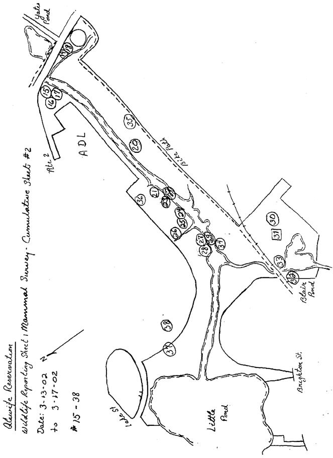
#37. This appears to be a woodchuck den in the process of being enlarged by another user, possibly a large predator such as fox or coyote. It is uncomfortably close to an established homeless site and so its future is in doubt once the warmer arrives along with the return of its human residents.
#38. The size, placement and composition of this scat identifies it as Eastern coyote with a high degree of reliability. It was placed on a pathway that is a vestigial woods road leading west from Acorn Park Drive toward Little Pond. It was a hair scat, copious and 1” in diameter, composed of fur and with the mandible of a vole showing on its surface. As the Belmont Uplands where this was found is the area of Greater Alewife most remote from human visitation, it is not surprising to find this sign here. A large prey base of cottontails and voles in the grassy and brushy areas which abound in the reservation provide a potential attraction to many predators adept at their capture. Whether the incipient den noted in #37 is associated with this sign will be checked later.
#39. A light snowfall provided an opportunity to get an idea of the density of prey species on the reservation. Here and nearly everywhere else in the park on this day, cottontail tracks were found in large numbers. This suggests a peaking of the local population. Like other prey species, cottontail populations tend to rise and fall, sometimes dramatically. In rich habitat, such as is provided by the many grassy openings and impenetrable brush and briar patches in the park, their numbers can reach very high density, followed by a crash as predator numbers increase to meet the abundance. March snow shows only one night’s activity before it melts, and so it is not accurate to base the number of available predators on one morning’s race around the park. However, it does suggest that the isolation of Alewife from other natural areas has provided a low predator to prey ratio that may be slow to catch up with the abundance due to the difficulty of reaching the park from natural areas to the west.
#42-45. After a light snowfall yesterday that recorded one night’s activity, many trails of housecats were found in the park, especially south of the river and on both sides of the railroad tracks, i.e. including Blair Pond. Only two trails were found north of the river, one near ADL and one in the field east of the ADL parking lot. South of the river, however, their trails were everywhere and coincident with the plentiful cottontail trails. Evidence of successful predation was not found, but it is likely that the many vole runways in the grassy areas in addition to the rabbit sign provide the attraction for these cats. At one point, as noted in #35, two of these cats were observed together. This observation occurred at dusk as nightly hunting was about to begin. When two cats are found hunting together rather than antagonistic toward one another, the suggestion is that there may be a feral cat colony somewhere in the area.
#46. This scat was composed mostly of clay with some hair. Like dogs, wild canids sometimes eat dirt, and foxes readily eat earthworms in appropriate soil. The soft alluvial soil in the reservation is easy to dig and has a high population of these worms, which are also the main prey of woodcocks. The size and placement of this scat, on a vestigial path, is consistent with either fox or small coyote.
#47. Another hair scat was found in the same general area as #38. The identification as Eastern coyote has a high reliability. A track trap was prepared along the vestigial path through the area. Since coyotes often defecate after arising from a lay site, two scats in the same area suggest that the animal(s) may be using the area as a refugium
#48. Canid tracks were found in the muddy path east of the ADL parking lot. The one clear track available is consistent with Eastern coyote with moderate reliability.
#50. At the edge of the large homeless area on the north edge of Yates Pond, several young aspens have been cut, presumably for firewood by the homeless residents. However, two trees showed incisor marks and a path through the cattails led to the water. Apparently the beaver(s) from Little River have come up through the ditch that drains the parking garage and into the pond, cut the trees and dragged them out the same way.
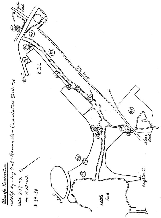
#51. A single canid track appeared in the muddy grass behind ADL and near the river. It was consistent with Eastern coyote with moderate reliability. The placement of this track, the ones found in #48 and the hair scats in #38 and #47 suggest that one or more animals may be laying up during the day in the Belmont Uplands tract and ranging downriver to the cottontail/vole habitats around the east end of the river at night.
#52. During an early morning visit to the south bank of Little River, a muskrat was observed swimming downriver past the observation point at close range. It seemed healthy despite the condition of the water.
#55. Shortly after the sighting in #52, a beaver appeared downriver swimming up against the flow. Sensing my presence, it tried to swim underwater past the observation point, but the water was so shallow that its progress was easily followed by rippling on the surface. The animal surfaced once or twice at close range and showed itself to be of moderate size and apparently healthy. So far, sign of beaver has been found downriver as far as Yates Pond and upriver as far as Wellington Brook. It appears the animal or animals are using the river and its tributaries and associated waters as a linear habitat. How far down Alewife Brook the beaver is ranging is unknown, but its preference for aspens suggests that beaver presence at the moment is probably localized to the study area of the reservation.
#57. In the field near Perch Pond a predator had half-consumed a cottontail rabbit. The event was very recent as the flesh was still crimson and soft, and flies had just begun to gather. It is unusual for a predator to flee and leave its food behind. Possibly my sudden appearance in a place where few humans go, startled it into fleeing too hastily to carry off its meal. Or the predator could have been the red-tailed hawk that hunts this and other fields in the reservation. Hawks have fairly weak feet, compared to owls at least, and so may have temporarily left its prey while I was in the area.
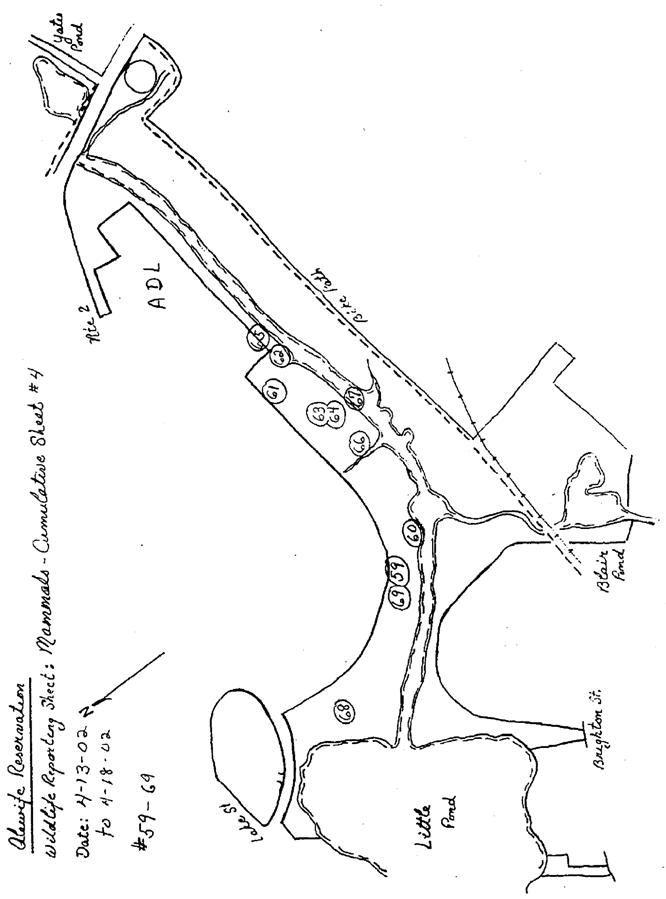
#58. The presence of white-tailed deer in the reservation has been reported sparingly in the past, but this was the first sign of their presence during the current inventory. The scat was of the summer type and was deposited in a field. Deer often gravitate to grassy areas early in the spring before other herbage “greens up”. Normally grass is not a favored food since it contains abrasive crystals that wear down teeth, an anti-grazing protection that grass has developed over the eons, but when deer have been slowly starving all winter, they will graze virtually anything green despite the harm. The identification of this scat as that of deer has a high level of certainty. It was probably deposited last spring. By the time roughage passes through the four chambers of a deer’s stomach and then passes out through its gut, there is little of bacterial interest left, and so it lies in place for a long until it finally weathers away.
#59. This is the third definite Eastern coyote scat I have found north of the river and west of ADL. Like the others it was a hair scat, but with more whitening: a characteristic of age and bone dust. I didn’t fractionate it for content, intending to leave that for a docent training session. The identification as coyote has a high level of certainty.
#60. Root humps of trees leaning over water are frequent sites for mammals to deposit scat as they patrol the bank. This site has been the location of raccoon and probably mink scat in the past. Some of the raccoon deposit was still in place when a weasel happened along, prompting it to deposit its own scat in response. This is often a habit of carnivores. The identification carries a moderate certainty; the animal was probably the long-tailed species.
#61. By size and location this appears to be the fifth scat of Eastern coyote I have found in the area. This was an old deposit that had been trodden on, probably by woodcock watchers going to the nearby field. However it was carnivore scat and placed at the high point of a rudimentary trail, a favorite location for coyotes marking their passage. The identification carries a high degree of certainty.
#62. Since the egg was not pipped, this appears to be predation. Raccoons may raid the nests of Canada geese along with those of other birds. But the site lacked sufficient evidence to determine the predator. The fact that the remains of a goose are nearby, which I attributed to coyote, may only be coincidence.
#63. This fur was not present a week ago. Its presence in an area that shows several signs of coyote suggests that this may be the predator. Raptors usually carry off prey to a plucking site to consume it while coyotes may feed at the kill site.
#64. This scat was found in a field that has shown other coyote sign.
#68. A very small fur scat was found on a trail from Acorn Park Drive into the woods. By size and composition it appears to be that of a weasel, probably the long-tailed species. The identification carries moderate certainty.
#69. A small shrub growing in the middle of a field showed definite signs of browse by white-tailed deer. The location is on a worn deer trail in which scat has been found (see #58). The sign was very old.
#70. In a genet of staghorn sumac were found two buck rubs by white-tailed deer. These are wounds on the lower part of a thin tree, often an aromatic and smooth barked species, where bucks rub the base of their antlers against the bark, abrading it. Although it is clearly marking behavior, there is some question about its exact purpose. Although does are known to notice it, they do not find it particularly stimulating, and so it is thought that it is probably an inter-sex signal among local bucks. The sign was at least two years old.
#72. At the edge of the small field and within a few yards of the river bank above Perch Pond was found a site with several Canada goose feathers. Most had been pulled out of the bird, but one had been bitten off. No skeleton was found, indicating that the carcass had been moved from the site. Circumstantially this would appear to be coyote predation of a sort that I have interpreted in the recent past at Quabbin Reservation, Great Brook Farm State Park and in the Middlesex Fells. With the abundance of Canada geese in Massachusetts, coyotes have learned to hide beside water and wait until a bird, either on the water or feeding on the bank, comes within a few yards. The coyote then charges the bird and seizes it by the neck, completing the kill and, if the kill was made in water, dragging it ashore to feed. The carcass is sometimes then dragged away by other coyotes or scavengers.
Predatory birds typically pluck their prey by pulling out the feathers, while mammalian predators often bite them off. As there are few predators, bird or mammal, capable of taking a goose, coyote is the likely candidate with moderate certainty. Judging by the fade of the feathers and the fact that some were covered by storm-beaten grass, the sign was quite old.
#74. Two scats of different ages were located at the junction of a foot trail and the bike path. The older scat was composed of short fur, probably mouse or vole; the fresher scat, which was placed on top of the first, was composed of vegetation and mucus. Wild canids often use scat to mark the intersections of trails they follow, and are often stimulated to deposit scat by the presence of other scat, that of their own species as well as that of others. Size, composition and location point to red fox as the depositor with a moderate degree of certainty.
#75. Red foxes leave urine scent marks that are usually detected as a whiff of skunk, the source of which is difficult to locate. Such was the case here, where the object that was marked was not determined due to a strong wind. However, the site was next to a small field where fox scat was found earlier in the survey. It should be noted that other mammals, primarily members of the weasel family including skunks, also have musk glands that they discharge when threatened or excited. In these cases, however, the discharge is generally copious and pervasive rather than slight and elusive. The attribution to red fox carries a moderate degree of certainty.
#76. On a trail through the brushy woods in this area was found a dead shrew. Although the end half had been removed, the size was consistent with short-tailed shrew. Some bloody tissue next to the carcass may have been regurgitated material: shrews exude a toxic fluid when attacked, inducing vomiting by the predator.
#77. A large hair scat had been deposited on a pile of vegetation along Acorn Park Drive at the west end of ADL where the vestigial trail leads into the woodcock field. It was so fresh that it was still warm. Odor, placement and size indicate Eastern coyote with a high degree of certainty. This is the freshest positive sign of this species so far in the survey and suggests continuing presence. The composition was hair with considerable mucus. After it ages, it will be fractionated for content. Several other older coyote scats have been found in the same area.
#78. A fresh hair scat was found at the same junction of trail and bicycle path as #74. Once again, by size, composition and placement the depositor was a red fox with a moderate degree of certainty.